ArchiDiariesAcademic projectsWater & Culture, Adaptation & Integration: Integrated Urban Transformation for River Flood Resilience and Sustainable Leisure Industry in the City of Maastricht | Urban Design Thesis
Water & Culture, Adaptation & Integration: Integrated Urban Transformation for River Flood Resilience and Sustainable Leisure Industry in the City of Maastricht | Urban Design Thesis
Project Name: Water & Culture, Adaptation & Integration: Integrated Urban Transformation for River Flood Resilience and Sustainable Leisure Industry in the City of Maastricht
Excerpt: ‘Water & Culture, Adaptation & Integration: Integrated Urban Transformation for River Flood Resilience and Sustainable Leisure Industry in the City of Maastricht’ is an urban design thesis by Danyi Xiang from Faculty of Architecture and the Built Environment – TU Delft, that seeks to explore integrated urban transformation in Maastricht to adapt to river flooding and promote sustainable leisure industry. It proposes transforming the urban fabric to prevent damage and transform floods into resources for sustainable leisure industry development across regional, city, and neighborhood scales.
Introduction: The survival and development of the city of Maastricht are facing enormous threats from the increasingly frequent and severe fluvial floods, while the leisure industry is the most vulnerable to flood damage as a crucial segment of the economy, accounting for about 50% of the total economic damage. However, flooding is essentially just a natural process with numerous ecological benefits, and can even stimulate diverse recreational activities under certain conditions.
Therefore, this thesis aims to explore integrated transformation from an urban design perspective for the city of Maastricht to adapt to river flooding and to promote sustainable leisure industry. It implies a transformed urban fabric that prevents the damage caused by river flooding and converts floods into a resource for sustainable leisure industry development through a series of spatial interventions and programs that cross three scales (regional scale, city scale, and neighborhood scale).
The Maas River is an important river in Western Europe, originating from the Langres Plateau in France, flowing through the industrial areas of the Netherlands, Germany, Belgium, and France and other Western European countries, and finally joining the Rhine estuary in the Netherlands to form a delta and injecting into the North Sea, with a total length of 925 km. It has a variety of socio-economic functions such as navigation, drinking water supply, flood safety, ecology and recreation.
Vulnerability Of the Leisure Industry to Fluvial FloodingVulnerability Of the Leisure Industry to Fluvial Flooding
The Maas is a rain-fed river, which causes dramatic fluctuations in river flow, with low flows in summer and high flows in winter. Maastricht is located at the junction of its middle and lower reaches and is a densely populated and important city in the Maas river basin. Over the past century, riverbed degradation in the Dutch section of the Meuse River has been ubiquitous. The hard sand deposits and gravel layer breaks up due to increased river discharge, resulting in degradation of the riverbed.
Recreational Value of Fluvial Flooding
The construction of dams and weirs, as well as intensive dredging, river normalization works and river bend cut-offs have led to bed degradation of the river Meuse in the last 100 years. This has resulted in a bed degradation of about one to three meters, depending on the length of the river. And after the 21st century, peaks in discharge will be more frequent and more severe due to global warming, while annual low tides will be longer and discharge will be less, which exacerbates the degradation of the riverbed, and the degradation is expected to continue for decades.
Design Process
Conceptual Framework
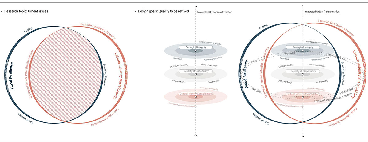
Conceptual Framework: The study explores the relationship between flood resilience and the sustainable leisure industry, focusing on how flood resilience measures can be integrated into leisure facilities and activities. It also explores the role of the sustainable leisure industry in enhancing flood resilience through infrastructure design, public awareness, and community engagement. The research aims to provide insights and recommendations for improving leisure spaces’ resilience.
Transformation Opportunities at Maas Basin Scale
Transformation Opportunities: Flooding in the Maas River basin, particularly along Belgium-German border, can be mitigated by buffer zones. The region’s geographical characteristics, including sloping terrain, make it ideal for water harvesting, with the plateau offering the most favorable conditions for effective initiatives.
Scope of Integrated Opportunities at Maas Basin ScaleScope of Integrated Opportunities at Maas Basin ScaleElements of the Cultural Landscape of Maastricht in Different Periods
Scope of Integrated Opportunities at Maas Basin Scale: Using flood control as an opportunity to promote transnational cooperation projects in this region will not only make full use of wasted land for flood control, but also take advantage of the diverse cultures at the border to drive the economic and cultural development of the surrounding cities. This approach can also raise awareness and willingness of local residents to participate in regional cooperation.
Value Dynamics of the Maastricht Cultural Landscape Key AreasPotential Space to Expand the value of Maastricht
Value Dynamics of the Maastricht Cultural Landscape Key Areas: The study categorizes Maastricht’s cultural landscape elements into four areas based on functionality, historical memory transmission, and ecological services. The study highlights the urgent need for flood protection due to the 20% increase in the Meuse River’s flow due to climate change. Floods will occur more frequently, making flood protection crucial for Maastricht’s cultural landscape. The study calculates catchment routes and junctions using GIS and DEM maps of the ahn.
Potential for Transformability at Maastricht City Scale
Potential for Transformability at Maastricht City Scale: The study used angular choice analytical integration analysis within the spatial matrix method to identify key urban road networks within a 5 m walking distance and assess the accessibility of neighborhoods within an 800m walking distance. The overlay of the highest values helped identify areas with the greatest potential for enhancing accessibility.
Potential Analysis of the Spatial Types at Neighborhood Scale
Potential Analysis of the Spatial Types at Neighborhood Scale: The spatial potential map in Maastricht is complex for design orientation, necessitating a detailed assessment at the neighborhood level. Despite different conditions, many neighborhoods share similar potential characteristics. The city’s potential spaces can be categorized into six main categories, emphasizing the need for a systematic approach for sustainable urban transformation.
Transformation Opportunities from Resident’s PerceptionTransformation Opportunities from Resident’s Perception
Maastricht Residents’ Perceptions: According to the perceptions of Maastricht residents, the city can be broadly categorized into three zones: the city center as the vibrant core, the natural areas surrounding the city as the scenic zone, and the other neighborhoods as neglected places lacking identity or interest.
Potential Space Types at City ScaleVisioning Typology Map at City Scale
Based on these perceptions and the identified needs of residents, including walkability, increased leisure activities, improved public transportation connectivity, affordable housing, and reduced overcrowding in the city center, this study proposes preliminary design directions. These directions aim to address the identified challenges and capitalize on the city’s potential:
1- Greening individual neighborhoods and enhancing accessibility and leisure activities
2- Stitching together Maastricht’s natural landscape fabric with green public transportation corridors
Final Outcome
Design Methodology
Design Framework: This study introduces a design framework aiming to achieve ecological integrity, equality of opportunity, and cultural identity consolidation in the context of flood resilience and leisure industry sustainability. It provides specific design directions for six spatial types and demonstrates their application at neighborhood and regional scales. This approach ensures the benefits of urban design interventions are realized on a broader scale, resulting in significant advantages.
Pattern FrameworkPattern Network
Pattern language: This study adopts a pattern language approach, organized into three distinct levels: guideline, strategy/program, and implementation. This hierarchical structure allows for a logical progression from abstract concepts to concrete actions.
At the guideline level, outlines principles and objectives for urban transformation focusing on flood resilience and leisure industry sustainability. Moving to the strategy/program level, It then explores various spatial and social strategies, tailored to the unique urban context. The implementation level involves applying these strategies in specific spaces within the urban environment, considering conditions, constraints, and opportunities. This comprehensive approach aims to address the challenges of flood resilience and leisure industry sustainability.
System of Leisure Culture City: The Leisure Culture City aims to create a vibrant urban environment with efficient public transport and diverse leisure activities in Maastricht city. Spatial elements are classified into historical, cultural, sport, leisure, and express elements. The proposal promotes connectivity through a comprehensive public transportation system and distributes recreational opportunities across different neighborhoods. However, environmental, educational, and energy sector involvement is needed for a comprehensive and sustainable urban development approach.
System of Eco-Water City: The eco-water city proposal in Maastricht aims to transform the city’s cultural landscape into bluegreen infrastructure, prioritizing flood resilience and ecological improvement. It involves creating a local water circulation loop, rainwater treatment, and water purification facilities. However, challenges arise in integrating private sector participation and addressing social issues during the implementation phase.
Conflicts and Synergies at Neighborhood ScaleVariation in Design at Neighborhood ScaleFlowing Culture City
Flowing Culture City: The Flowing Culture City plan outlines the city’s cultural landscape, focusing on public transportation and affordable housing. Three locations are used to demonstrate the plan’s effectiveness. Pilot projects demonstrate the integration of flood management strategies with leisure activities, showcasing how these elements can coexist harmoniously. This approach enhances the city’s spatial atmosphere and contributes to a harmonious coexistence of these elements.
Benefit Densification: BeforeBenefit Densification: After
Benefit Densification Implementation: The design approach for converting industrial areas into residential spaces combines architectural preservation with new elements like housing, restaurants, and amenities. Vertical expansions create affordable housing, while underground space is repurposed as a rainwater reservoir. The community is designed to be flood-resilient, featuring an elevated track system for uninterrupted access during floods. This innovative approach also offers open water recreational activities, promoting equal opportunity and job creation in social housing-dominated communities.
City Skeleton: BeforeCity Skeleton: After
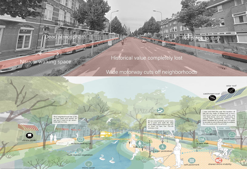
City Skeleton Implementation: The main streets of Maastricht suffer from a predominant presence of cars, leaving very limited room for pedestrians and a lack of inviting spaces. This results in a lifeless urban environment.
However, a solution presents itself in the form of a boulevard positioned in the center. By introducing this boulevard, the continuous flow of vehicular traffic is disrupted, and the addition of a canal revitalizes the spatial ambiance reminiscent of the city’s old walls. Moreover, this canal helps regulate the local microclimate and creates a pedestrian-friendly atmosphere. Furthermore, the inclusion of seating areas and ground-floor amenities encourages people to spend more time, fostering a vibrant street environment.
Integrated Implementations of the Neighborhood ScaleBuffer: BeforeBuffer: After
Buffer Implementation: Maastricht’s agricultural areas along riverbanks are currently protected by levees, which are inefficient due to high maintenance costs and river view obstruction. To address these issues, transforming agricultural areas into water-adapted systems, like fish farms, could eliminate the need for dike protection, promote agritourism, and reduce maintenance costs. This shift also offers economic benefits, reduces maintenance costs, and enhances biodiversity. The integration of multi-layered vegetation supports high water tourism, demonstrating how flooding can be turned into a resource, promoting ecological sustainability, income generation, and tourism.
System Performance of the Flowing Culture City
System Performance of the Flowing Culture City: The study proposes six urban design typologies to enhance Maastricht city’s retention capacity, address future weather extremes, and provide diverse ecological services. It also aims to foster leisure activities with urban features in each neighborhood, potentially generating significant employment opportunities, while leveraging the city’s cultural landscape.
Connectivity of Maas River BasinIntegrated Design Models
Connectivity of Maas River Basin: The increased connectivity of the cultural and natural environment in the Maas River basin can have reciprocal benefits for urban development and the environment in Maastricht. This includes improving transportation connectivity, particularly for navigation, ensuring uninterrupted during river flooding, and promoting ecological circulation and leisure activities in the suburban interface.
Integrated Design Models
Conclusion: The study proposes a landscape structure incorporating cultural cores and corridors to enhance flood resilience and promote sustainable leisure industry development in Maastricht. This integrated urban transformation scheme can increase retention capacity by 34% and create 800 new job opportunities. It also prepares Maastricht for major flood events until 2060.
[This Academic Project has been published with text submitted by the student]
Site Context
Design Process
Final Outcome
To submit your academic project for publication at ArchiDiaries, please visit the following link >> Submit